
Rapid tram
Example of the corridor between Luxembourg City and Esch/AlzetteA first transport corridor, running alongside the A4 motorway between Esch-sur-Alzette and Luxembourg City, is being analyzed for the year 2035.
1. Observation
- This is the corridor that connects the two largest urban areas in the country, Agglo LUX and Agglo SUD.
- Due to the outlying locations of the bus stops and the route via Bettembourg, CFL line 60 is not competitive with cars on several routes that will be important in 2035, for example, between the northern districts of Esch and the southwest of the capital, two areas slated for significant growth.
- In 2018, during peak hours, a bus ran approximately every three minutes on the A4 motorway, carrying a total of 5,500 passengers per day. The buses are caught in traffic jams daily.
2. Demand in 2035
- Even if an additional 15,000 passengers per day and in each direction were diverted to CFL line 60, and if an additional 10,000 passengers carpooled on the A4, at least 15,000 trips would still need to be shifted to public transport and the express cycle path along the A4 (calculation based on a Statec medium-growth scenario).
- To encourage such a large number of people to use public transport along the A4, a connection that is as fast as possible and ideally direct to Kirchberg will be necessary, with the possibility of reaching other points of interest in the capital with just one transfer.
3. Constraints and opportunities
- The bottleneck created by the Natura 2000 bird protection zone at Leidelengerbësch will likely necessitate a choice regarding which modes of transport to prioritize.
- In Luxembourg City, the Cessange and Merl boulevard projects will extend the route on a dedicated right-of-way, while also serving these new neighborhoods.
- A dedicated bus lane currently being planned between the Lankelz and Foetz interchanges will help redirect some of the dispersed demand to a potential transport hub at Foetz.
- The redevelopment of the Esch-Schifflange industrial brownfield sites could be structured around a high-performance mode of transport.
4. Choice of main mode of transport
Three alternatives were analyzed to reach the minimum target of 30,000 trips per day in both directions:
- A dedicated bus lane on the A4 motorway would have insufficient capacity by 2035 and would only be attractive if a very large number of buses directly served the main attractions in the heart of the capital, which contradicts the City's transport policy.
- Paradoxically, a metro or monorail line would be both significantly oversized relative to demand and would have a lower passenger potential than a road system, since an underground or elevated transport system could not serve all the main attractions in the two metropolitan areas.
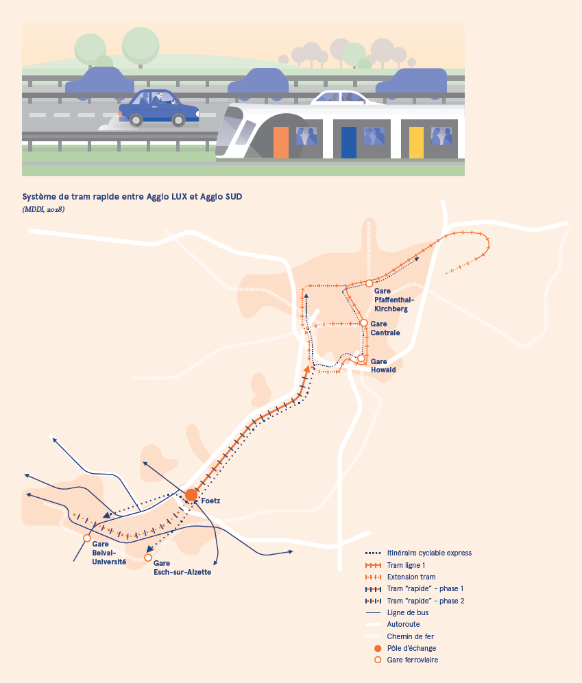
- Implementing a "rapid" tram line would provide detailed service to the urban areas at both ends of the corridor, while ensuring sufficient speed (approximately 100 km/h) along the A4 corridor to offer attractive journey times. From the outside, the rolling stock could be identical to a purely urban tram, the only difference being the motor and brakes. This system would offer sufficient capacity and could be integrated into the Luxembourg City tram network. On the southern side of the corridor, such a system would serve the main development hubs (Esch-Schifflange brownfield sites, Lallange, Belval, etc.), provide direct and rapid connections with Luxembourg City, and serve as a structuring axis for the part of the southern conurbation with the highest demand for travel.
5. Choice of multimodal concept and proposed phasing
A phased approach will provide a medium-term solution while awaiting the implementation of the "fast" tram by 2035.
- In the medium term, service will be provided by a system of several high-quality bus lines which, from various hubs in the south of the country and the border region, will connect to two or three termini within the Luxembourg City metropolitan area. The possibility of transferring between lines within the Esch-sur-Alzette metropolitan area must be offered to increase the number of possible origin-destination routes. These lines will utilize the dedicated bus infrastructure planned between the Lankelz and Foetz interchanges and potentially other prioritization measures between Foetz and Leudelange. Simultaneously, an express cycle route will be established. This will connect Belval, Esch-sur-Alzette, and Schifflange to the Luxembourg City cycle network at Hollerich and Cloche d’Or. Given the urban planning and environmental bottlenecks, particularly between Foetz and Leudelange, the route and clearance required for a "rapid" tram must be reserved in all medium-term planning.
- By 2035, the "rapid" tram will be able to connect Belval to the Esch-Schifflange brownfield site and the Luxembourg City tram network. The precise type and location of the connection within Luxembourg City will depend on the tram network's development phases and operational constraints. To ensure access to the "rapid" tram for other localities, an interchange hub will be planned in the Foetz area. This hub will allow bus lines to connect to a location where the less frequent, and therefore slower, service to the Esch urban area will no longer impact travel time. The dedicated bus lanes along the A4 motorway between Lankelz and Foetz will remain in use for this purpose.
Impact
The implementation of this high-performance multimodal concept between the country's two main urban areas will create a key transport corridor. The very prospect of such an implementation will facilitate more organized and harmonious development of the region in the years and decades to come. Demographic and economic growth in both urban areas will gradually become less affected by the traffic problems the country experienced in 2018. According to the tram network's operating plan, several key direct connections are envisioned: CHEM – CHL, Uni Belval – Uni Kirchberg, Esch-sur-Alzette – Findel, etc.
What's next?
This analysis of the corridor between Esch-sur-Alzette and the City of Luxembourg, which still needs to be refined, constitutes the first piece of the puzzle on which the MMTP has begun to work for the whole territory, the objective being to formulate a coherent multimodal concept for the mobility of the Grand Duchy and the border regions by 2035.
Last update